Observatory History | The Early Years
The CNES Satellite Tracking Station
THE CNES YEARS
Stephanion and the Dawn of the Space Age
In March 1966, a scientific mission from the French National Centre for Space Studies (CNES) visited Greece in search of a suitable location for a station to track French scientific satellites. France had already entered the Space Age and, just one month earlier, in February 1966, had launched its second satellite, Diapason D1A, aboard a French Diamant A rocket from Hammaguir in Algeria. CNES was now preparing for the launch of the geodetic satellites Diadème D1C and D1D in February 1967.
To improve the accuracy of satellite tracking, CNES sought to complement its existing stations in southern France and Algeria with a third station in the Eastern Mediterranean. After surveying several locations in Greece, Stephanion Observatory in the Corinthia, was selected. In October 1966, a cooperation agreement was signed between Greece and France, and the station became operational under the direction of P. Foussier.
The pioneering experiments carried out during this period were among the earliest practical applications of laser technology to satellite tracking. Stephanion’s participation placed the Observatory at the forefront of European space research during the early Space Age and marked an important chapter in the development of Satellite Laser Ranging (SLR) — a technique that remains fundamental to modern geodesy and Earth science today.
Did you know?
The “French Laser Men”
In the pioneering years of satellite laser ranging, French scientists and engineers earned an unusual nickname from their American colleagues: the “French Laser Men”. Impressed by the number and quality of the laser measurements achieved by the French teams, their international partners began using the name as a mark of recognition.
Their work placed France at the forefront of the emerging field of Space Geodesy. In 1967, Stephanion Observatory was one of the three ground stations operated by one of these Teams, that participated in the first successful simultaneous laser-ranging space triangulation experiment using the French geodetic satellite Diadème D1D—a pioneering achievement in the history of satellite geodesy.
THE CNES YEARS
The Diadème campaign
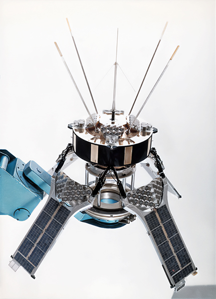
The Diadème campaign, organized by the French space agency CNES in 1967 following the launch of the D1C and D1D satellites, aimed to establish a highly accurate geodetic triangulation network across the northern Mediterranean.
The observing network combined several techniques. In France, the Observatoire de Haute-Provence operated a laser ranging system, a Doppler station and a Schmidt telescope, while the ANTARES camera was located in Nice. In Greece, Stephanion Observatory in the Peloponnese operated a CNES laser ranging system together with a Doppler station. Additional observations were made with a Baker–Nunn camera at San Fernando near Cádiz, Spain, and a Doppler station at Colomb-Béchar in Algeria.
During the campaign, more than 80,000 laser distance measurements were obtained, with the three principal stations synchronized through the physical transport of precision clocks. Although all satellites equipped with laser reflectors could be observed, priority was given to French satellites.
Combining laser ranging, Doppler measurements and photographic observations produced station-positioning accuracies of approximately 10 metres. However, the campaign demonstrated that the much greater precision of laser ranging could only be fully exploited if all three vertices of the geodetic triangle were equipped with laser ranging systems.
This finding led to the RCP campaign of 1968. By then, the CNES laser station had been transferred from Stephanion to Cádiz, while the Smithsonian Astrophysical Observatory installed a laser ranging system and Baker–Nunn camera at Dionysos near Athens. Doppler stations were no longer used. Observations concentrated on Diadème D1D, GEOS A and GEOS B, combining laser ranging with simultaneous photographic observations of the satellites’ light flashes.
With this improved all-laser configuration, the uncertainty in determining the positions of the observing stations was reduced from about 10 metres to approximately 2 metres.
SPACE GEODESY
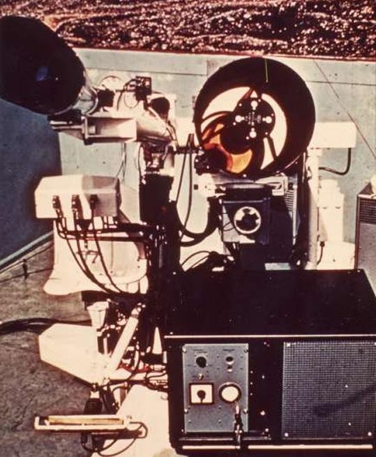
The Laser Satellite Tracking System
In 1967, the Stephanion Satellite Tracking Station became one of only three observatories participating in an ambitious international experiment to measure satellite positions with unprecedented precision using laser technology. Organized by the French National Centre for Space Studies (CNES), the campaign brought together leading French scientific institutions, including the Bureau des Longitudes, the French National Centre for Scientific Research (CNRS), and ONERA (the French Aerospace Research Centre), with support from the Directorate for Research and Test Equipment (DRME).
Together with the stations at Saint-Michel-de-Provence in southern France and Colomb-Béchar in the Algerian Sahara, the Stephanion station formed a unique laser triangulation network. By simultaneously firing laser pulses at the French Diadème satellites, scientists could determine their position in space with remarkable accuracy. The measurements also contributed to improving orbital calculations and geodetic surveying techniques, demonstrating the potential of laser ranging for future space missions.
The laser telemetry equipment installed at Stephanion was designed and built by the research laboratories of the Compagnie Générale d’Électricité (CGE). At its heart was a liquid-cooled ruby laser producing intense pulses of coherent red light with a wavelength of 694.3 nanometres. Each pulse lasted only 25 nanoseconds but delivered an energy of one joule, reaching a peak power of approximately 50 megawatts. Although the system was capable of firing up to ten pulses per second, it was normally operated at one pulse per second to ensure reliable performance under varying atmospheric conditions.
These pioneering experiments represented one of the earliest practical applications of laser technology in satellite tracking. Stephanion’s participation placed the observatory at the forefront of European space research during the early Space Age and marked an important milestone in the history of satellite laser ranging, a technique that remains fundamental to modern geodesy, Earth science, and spacecraft navigation today.
SATELLITE TRACKING
The Doppler Station
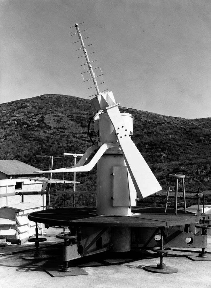
Alongside its laser-ranging equipment, Stephanion operated a Doppler radio-tracking station during the Diadème geodetic campaign. The system provided an independent method of determining the motion and position of the satellites by measuring extremely small changes in the frequency of radio signals transmitted from space.
The principle was based on the Doppler effect: when a source of radio waves moves relative to an observer, the frequency received by the observer differs slightly from the frequency originally transmitted. As a satellite approaches a ground station, the received frequency increases; as it moves away, it decreases.
Because the transmitted frequency was precisely known, measuring this change allowed scientists to determine the radial velocity of the satellite relative to the receiving station. The French Diadème D1C and D1D satellites, like their predecessor Diapason, carried a highly stable 4.999 MHz oscillator. Through frequency multiplication, it generated two continuous radio signals at 149.970 MHz and 399.920 MHz. Using two frequencies was essential. Radio waves passing through the ionosphere are slightly disturbed, and the magnitude of this effect depends on their frequency. By observing two precisely related frequencies simultaneously, scientists could largely correct for this ionospheric influence and obtain much more accurate measurements.
At the ground station, special directional antennas received the 150 and 400 MHz transmissions as the satellite passed overhead. The received frequencies were measured by counting radio cycles over 10-second interval, allowing frequency variations as small as approximately 0.1 Hz to be detected.
PIONEERING RESEARCH
A World First in Space Geodesy
In the late 1960s, the Stephanion CNES Satellite Tracking Station participated in one of the world’s first simultaneous laser-ranging experiments using multiple ground stations.
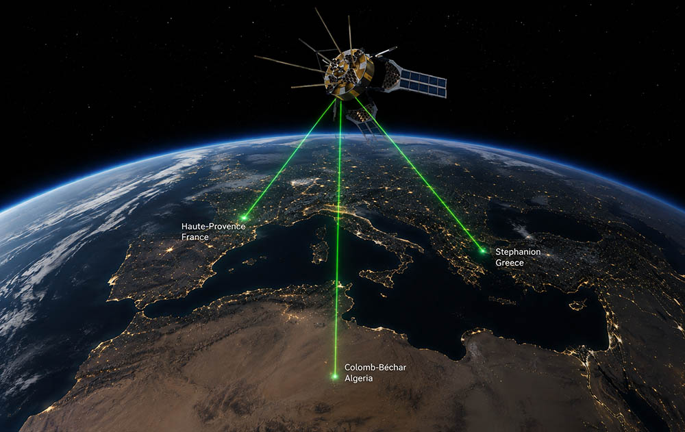
During a pass of the French geodetic satellite Diadème D1D, laser pulses were transmitted simultaneously from three stations located in Stephanion (Greece), Colomb-Béchar (Algeria), and Haute-Provence (France). The satellite reflected the laser signals back to Earth, allowing scientists to measure the distances with extraordinary precision.
This experiment marked the first successful space triangulation using Earth-based laser ranging, demonstrating that a satellite could serve as a reference point for accurately determining the relative positions of widely separated observatories. The achievement represented a major milestone in the development of satellite geodesy, paving the way for modern techniques used today to measure Earth’s shape, monitor tectonic plate motion, and establish highly accurate global reference systems.
Stephanion’s participation in this pioneering international experiment highlights the observatory’s important role in the early history of space-age scientific research.